Jul 1, 2022: Vancouver to face even more densification if the Vancouver Plan gets green light
Only two weeks after approving the contentious Broadway Plan, City Council faces a bigger, more expansive task to approve the hefty 229-page Vancouver Plan that will set the course for the city’s housing and much else for generations to come.
The meeting of the Standing Committee on City Finance and Services takes place on Wednesday, July 6 at 9:30 am; the Vancouver Plan will be the first item on the agenda.
Read the report on the Vancouver Plan: A long-range plan to guide growth and change.
Compared with the 500-block stretch of the Broadway Plan, the Vancouver Plan (VP) covers the entire city. Staff began work on a city-wide land use strategy in November 2018. The resulting report is now being rushed through for Council approval before the October election, with only one week’s notice. The new plan for neighbourhoods was made without applying neighbourhood-based planning principles or responding to the individual needs of affected communities.
The report states: “While Vancouver’s current framework of land use plans and policies as developed over many decades set the foundation for the city’s world-renowned liveability, that planning approach and its outcomes are not suited to the complexity of the current and emerging issues that this and future Councils will be called on to address. The absence of a coherent framework for long-term land use planning sets Vancouver apart from other municipalities in the province and puts at risk efforts to effectively manage the impact of inevitable growth and change.”
Instead, a new planning approach takes into consideration major issues such as housing equity, First Nations culture, climate change, transportation, and so on. In this letter, UKRA will focus on housing, transportation, and land use, and what the coming changes will mean for our neighbourhood.
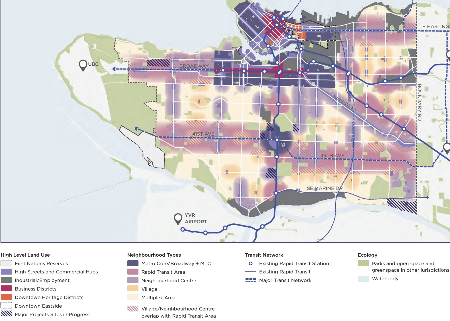
When the new neighbourhood types first appeared on the VP city map, Upper Kitsilano was colour coded in a mix of pink and light purple, designating it as both a neighbourhood centre and a rapid transit area. These labels would allow for building heights of 12 to 18 storeys and higher near subway stations. But later in the planning process, when the map was shown on the Shape Your City VP survey, Upper Kitsilano appeared as a neighbourhood centre only (which allows no more than 12 storeys). This confusion led UKRA to write to City Council. We heard back from most Councillors, who said they would report this to staff; however, the neighbourhood centre-only status on the survey remained unchanged.
Now comes a new updated map showing Upper Kitsilano as part neighbourhood centre, part village (which appears to run from the northeast corner of 16th Ave. and Macdonald St. along 16th Ave. to Vine St.), part rapid transit area in anticipation of the UBC subway extension. There may also be what looks like a multiplex area on one area of 16th Ave. Note the newly added purple stripes, which changes our neighbourhood to a “Village/Neighbourhood Centre [that]overlaps with a Rapid Transit Area.” According to the updated Vancouver Plan, “Where a Village or Neighbourhood Centre overlaps with a Rapid Transit Area, neighbourhood type will be determined based on transit investment timing, station location and more detailed area planning.” By “transit investment timing” we can only assume City planners mean “after the feds and province have coughed up $4 billion or so for the subway extension to UBC.”
UKRA has asked City Planning to clarify what will happen to our neighbourhood if the VP is approved, and if housing development—aka towers—could proceed whether or not the UBC subway is approved. City Council has already approved subway stations at Macdonald, Alma, and somewhere on the Jericho Lands in the West Point Grey neighbourhood. If and when the UBC extension proceeds, in keeping with the Broadway Plan, buildings near subway stations could rise to 40 storeys.
To clarify: The subway extension has been approved by Vancouver City Council and the Mayors’ Council, but the funding is still not in place.
One thing we can say with certainty is that there will be increased density on all blocks, generally descending in height as one moves away from the arterial streets. As we’ve said many times before: This change in building typology applied throughout the city has been ordained without applying neighbourhood-based planning principles or responding to local context.
The VP means:
- Significantly higher density development across the city
- New regional designations for Major Transit Growth Corridors along existing bus routes
- Expansion of transit development corridors and areas
- A push for development growth near neighbourhood centres, with up to 12 storeys on side streets, 12 to 18 storeys close to stations, and even higher towers at stations and major projects
- Multiplexes allowed throughout RS and RT zones covering the rest of the city
- Little to no reference to neighbourhood character or heritage buildings
- Incorporation of major plans such as the Broadway Plan, Jericho Lands, etc.
- An overriding of Community Plans and Visions
All of the above is promoted by this Council using untested growth of housing targets that are not based on transparent data.
We will keep you updated as information about Upper Kitsilano becomes clear.